Scaliscro & Morsgail - 17/05/05
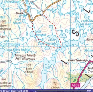
Head out to the Scaliscro road end, along the Uig road, 2 miles east of Morsgail. Set off on walk at 12.45; along the B8011 for a few hundred yards then it's off on an all-terrain vehicle track. This leads along a non-descript valley. The trail is pretty much dried out at the moment, but could well be a veritable bog after heavy rain. The way climbs gradually past Loch Ruadh / Red Loch. The view opens out before me. When I reach the highest point at 90 metres (300 ft), at GR 175232, there is a choice of routes. I can traverse the valley west, and cut along the northern bank of Loch Coire Geurad, head east along the slopes of the hills towards Roineabhal or continue south towards Loch Bruaiche Breibhat and Loch Coire Geurad. I opt for the last route and carry on down the ATV trail. The view is clear along the length of Loch Langabhat. From Roineabhal south, I can see all the hills along the loch's eastern shore, and some of the Eishken hills beyond. The track from Aline can be seen snaking its way down below Creag na Clibhe. The highest summits between Clisham and Stuabhal are wreathed in rainclouds. It almost looks as if there is snow on the summit of Stuabhal, but the temperature (9C) is just too high for that. Coltraiseal Mor blocks off the view due west. I carry on downhill and presently am on the strip of land between Loch Bruaiche Breibhat and Loch Coire Geurad. The ground is broken in places, but there are no major problems with bogs. I lost the trail in place, and blaze my own. Regain the ATV track beside Cul Laimhe Mor. There are a few sandy beaches at the southern end of Loch Coire Geurad. To the east, I can now see Ciorabhal. At about 2.30, I jump over the outflow of the loch and reach the Stornoway Angling Association hut. There are two boats (SAA1 and 2) tied up. The door is triple locked. Just as I finish a late lunch, at 2.45, the rain starts. So I pack up and head west over the hills. After half an hour, I reach Loch Lomhain, a bit further south than I'd hoped. However, it's easy walking on the grassy if bumpy slopes of Ascleit. Now heading northwest along the shore of the loch, then up the hill of Druim Lomhainn. On the far side, Scalabhal Mula rears up to the left, and Coltraiseal Mor faces me broad side on. I aim for a point to the left of Loch Ruidh a Dheas, with Loch Ruidh Meadhanach far right. It's broken ground, but not too horrendous. On reaching the Oscaroe River, I can see straight out to Loch Roag, 2 miles to the north. I decide to cross the river, and pick up the Morsgail trail. It's boggy on the ridge of Liana Ban Mas Scalabhal (that's one name...). Head to the right of Loch Ruadh mas Scalabhal, and to the left of a nameless body of water. After a short teabreak on the ridge, just before 4 pm, I head down to and onto the Morsgail trail, and I reach the road at 4.15. Proceed to the gate by the rundown croft, and decide to take the ¼ mile shortcut to the main road. Find a sheep that has sunk into a bog by its 4 feet. The smell indicates to me that it is dead. It's just standing there with eyes open. Very unpleasant. Traverse a boggy meadow, which sometimes houses sheep. Today, there is not a cow and not a (live) sheep in sight. Except out on the road, but that's another story. Arrive there at 4.50






I wonder why the triple locks? Hmmm.....? Maybe they have gate crashing sheep? Lol!
ReplyDeletePoor old sheep...stuck there in the bog to admire the view forever. That's what I feared for you as I read your last entry Guido. Setting out on your own in boggy ground and slippery rocks. Must be the mothering instinct in me.....lol!
Another wonderful travail over beautiful landscapes. You elucidate these journey's so well I am there with you.
Thanks once again.
Jeanie